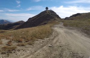
Updated 07/10/2021 The Bountiful Peak / Francis Peak ATV Ride is mostly on improved gravel roads that are fairly well maintained. With that, the ride is an easy ride without a lot of rough terrain to navigate.
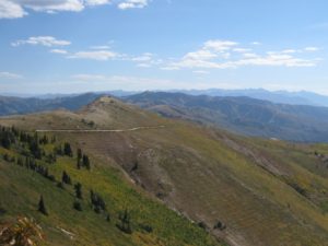
This ride starts at an elevation of about 5,200 feet and rises to 9,263 feet at Bountiful Peak. On the ride to Bountiful Peak, there are some spectacular views of Davis County cities along I-15 and of the Great Salt Lake.
There is plenty of oak brush along the route, as well as some aspen and pine. You will see wildlife and occasionally see a reptile (snake) crawling across the road. Be careful not to run over it. We would caution you that there are rattlesnakes at the higher elevation of this ride. (Photo) You will usually find them in rocky areas. We have seen them. Just be aware of your surroundings. Keep an eye out for them, and you will be fine.
When you arrive at Bountiful Peak, there is a place to park your ATV so that you can take the short hike to the top of the peak, which offers breathtaking views in all directions.
If you look north from Bountiful Peak, you will see Francis Peak. You will recognize it because of its radar domes. That is your next destination.
The ride to Francis Peak will take you east on the Morgan County side of the mountain for a while. You will see Farmington Lakes as you crest the ridge and start down the other side. The views will be completely opposite of what you saw on the Davis County side. Lots of pine and aspen trees along with views of many mountain ranges to the east. You will descend to an elevation of approx. 7200 feet where you will intersect the road coming up Farmington Canyon.
From there you will start your climb to Francis Peak and will eventually reach an elevation of around 9400 ft. Francis Peak is 9528 feet but is not accessible as there is a locked gate. But at this point, you will have beautiful views to the west and the east. The view to the east will give a good look at Morgan Valley and the city of Morgan. And on a clear day, you can even see as far as the Uinta Mountains. Just make sure you take your camera, smartphone, whatever. You are going to want to get some pictures.
Located east of Fruit Heights in Davis County, Francis Peak was once one of the craggiest peaks in the area. It was also among the first Davis and Morgan County peaks to be identified.
During this ride, you will see several places on the mountainside that have a number of terraces cut into the mountain. These were constructed in the 1930s by the CCCs to prevent water runoff from heavy rains and deep snowpacks. It’s a very interesting event. Take some time to Google it and read about it before you go.
From Francis Peak, there is a jeep trail that goes northeast over to Smith Lakes. On Smith Lakes Road, there are some great places there to pull off and have a relaxing lunch in the shade. Take some time to enjoy the rest and have a good visit. Hope you enjoy the ride.
We always recommend that someone at home knows where you have gone to ride. You should include some of the information in this ride package, such as the trailhead destination and coordinate, a copy of the trail map, and an approximate time you will be back. Some rides will have occasional cell phone service, but you cannot always count on that. We want you to be safe and have fun. Please don’t venture off without telling someone where you are going.
(All Directions begin at 10600 South Exit on I-15 in Sandy, Utah. Routes and travel times to trailheads will vary depending on your location.)
Google Map Coordinates: 40.895550° -111.845106°
Distance to Trailhead: 27 Miles
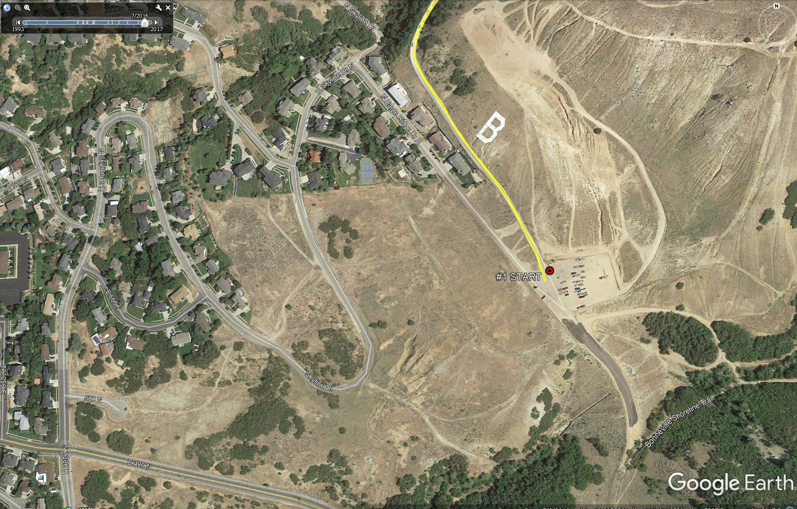
Take I-15 to Bountiful, Utah. Take exit 317 (400 North) and go east on 400 North. Travel east on 400 North until you reach 1300 East. Approx. 3.3 miles. Turn north on 1300 East which becomes Skyline Drive. Follow Skyline Drive approx. One mile to Eagle Ridge Drive. Turn Right on Eagle Ridge Drive and follow it to the parking lot at the base of the big “B” on the mountainside. This is where you will start. (See staging photo below for route to the parking area from 400 North)
(Click Photo to Enlarge)
POI # 1 Overlook of Great Salt Lake 40.954591°, -111.816493°
& Erosion Terraces Built by CCCs in the 1930s (Look left and right.)
Watch for Rattle Snakes off the edge of this pull-out. We have seen them.
POI # 2 Bountiful Peak: 40.964472°, -111.818413°
POI # 3 Francis Peak in the Distance 40.968328°, -111.820874°
POI # 4 Look Down on Lagoon: 40.966267, -111.822517
POI # 5 Farmington Lake 40.975341°, -111.817416°
POI # 6 Rest Room 40.981931°, -111.806619°
POI #7 View of Hill Air Force Base/Antelope Island 41.023672°, -111.839598°
POI #8 Francis Peak/View of Morgan 41.027563°, -111.838032°
(CLICK HERE) For a photo of the GPS Points of Interest to take with you. For instructions on how to download this photo to an electronic device, go to “How to Download Maps and Photos to a Phone or Tablet or to Print on Paper,” listed below.
NONE
Digital Waypoint Maps correspond with the GPS Points of Interest above and the Waypoint Information listed below. These are Real-Time Photos of the trail and contain a Latitude/Longitude Grid. Study them before you go. This will help you understand the trail route before you go. A good GPS is an important device to have when you are ATVing. (You cannot always rely on a cell phone for these coordinates as you don’t always have service.) You can check the Lat/Long coordinates on your GPS and use them to find exactly where you are on the digital Waypoint Maps provided for this trail. These digital maps can be downloaded to a phone or tablet as a picture (you don’t need cell service to look up a picture) or printed from your computer on a piece of paper. Instructions on how to do this are detailed below under “How to Download Digital Maps and Photos to a Phone or Tablet or Print on Paper.” (Additional types of maps can be found below under “Maps.”)
(Click on Icon or Map Title to See Map)
 BOUNTIFUL PEAK / FRANCIS PEAK WP Map #1
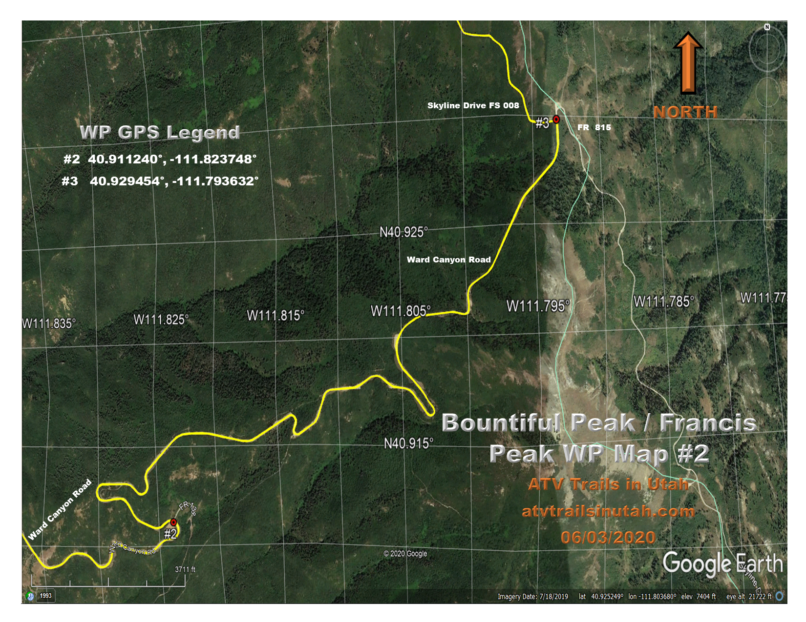 BOUNTIFUL PEAK / FRANCIS PEAK WP Map #2
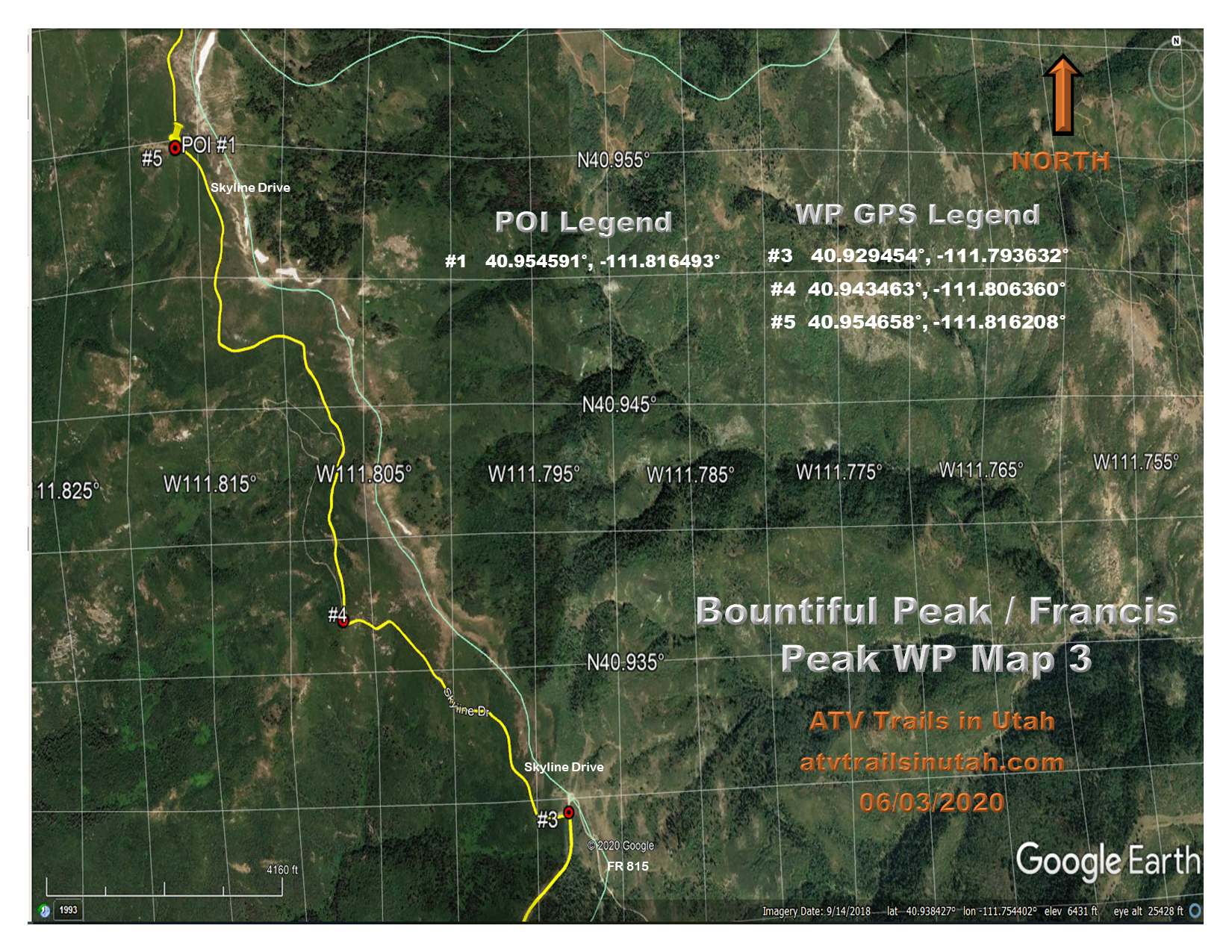 BOUNTIFUL PEAK / FRANCIS PEAK WP Map #3
 BOUNTIFUL PEAK / FRANCIS PEAK WP Map #4
 BOUNTIFUL PEAK / FRANCIS PEAK WP Map #5
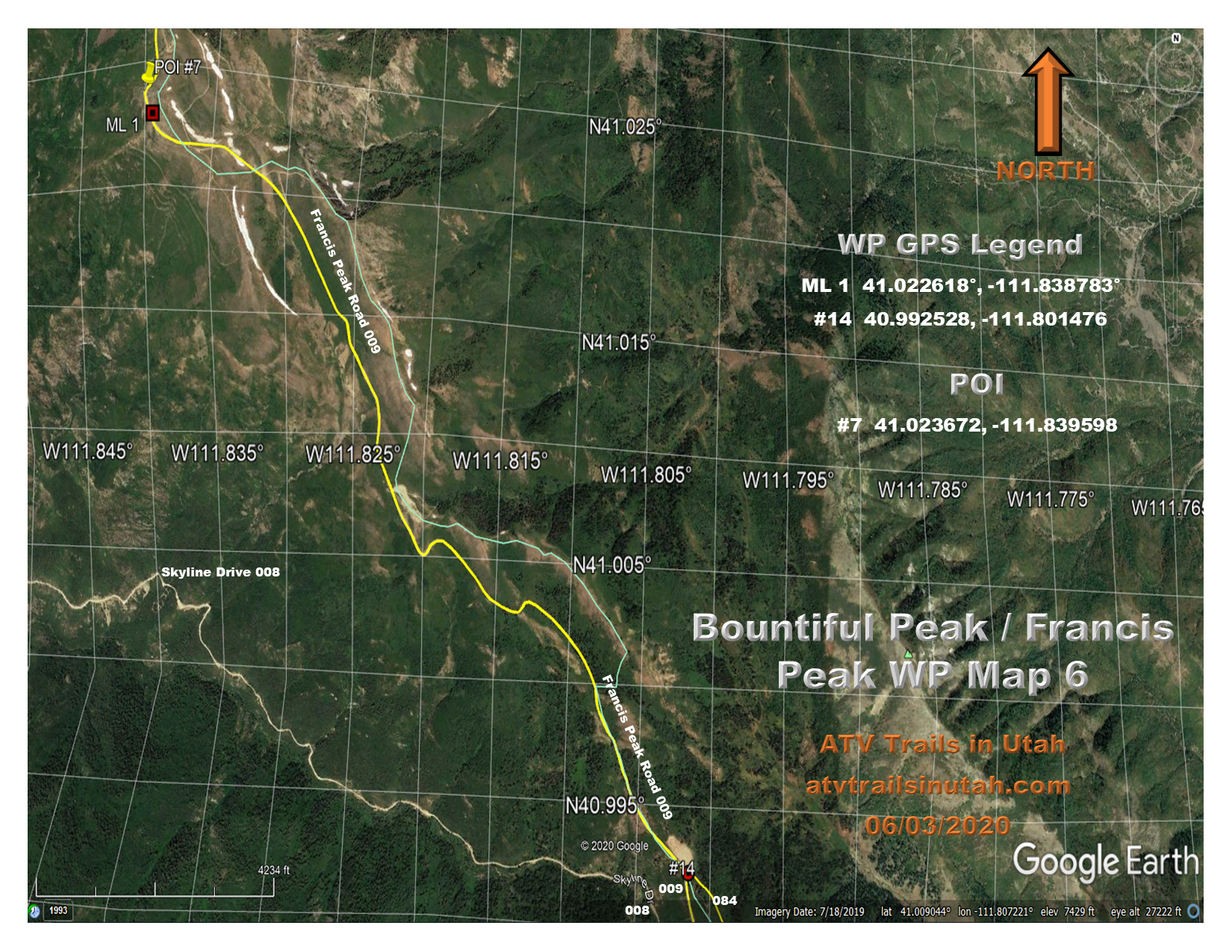 BOUNTIFUL PEAK / FRANCIS PEAK WP Map #6
 BOUNTIFUL PEAK / FRANCIS PEAK WP Map #7
 BOUNTIFUL PEAK / FRANCIS PEAK WP Map #8
 BOUNTIFUL PEAK / FRANCIS PEAK WP Information
Waypoint (WP) information corresponds with the maps listed above and the Google Earth file listed below. (To see the entire trail, download this file to Google Earth on your computer.) You can download the photos to your phone or tablet as a picture along with your Digital Waypoint Maps. Or you can print them on paper. Instructions on how to do this are detailed below under “How to Download Digital Maps and Photos to a Phone or tablet or Print on Paper.”
#1 Begin the ride by heading north out of the parking lot on Ward Canyon Road (FR 177). Stay on this road for 8.3 miles to WP #3 (Photo)
#2 Is a large parking area. Stay on Ward Canyon Road. (FR 177) (Photo)
#3 Turn left here (North). You are now on Skyline Drive (FR 008) (Photo)
#4 Stay right at this intersection or the upper road. (Photo)
#5 Pull off for POI #1. Great view of Salt Lake, Davis, and Weber Counties. Watch for Snakes off the edges of the rocks. (Photo) (Photo)
#6 Pull off for the hike to Bountiful Peak. This pull-off is 3.4 miles from WP #4. (Photo)
#7 This is where you go over the ridge down toward Farmington Lakes. FR 806 is to the left. Stay on the main road. (Photo)
#8 Farmington Lakes pull out. POI #5 (Photo)
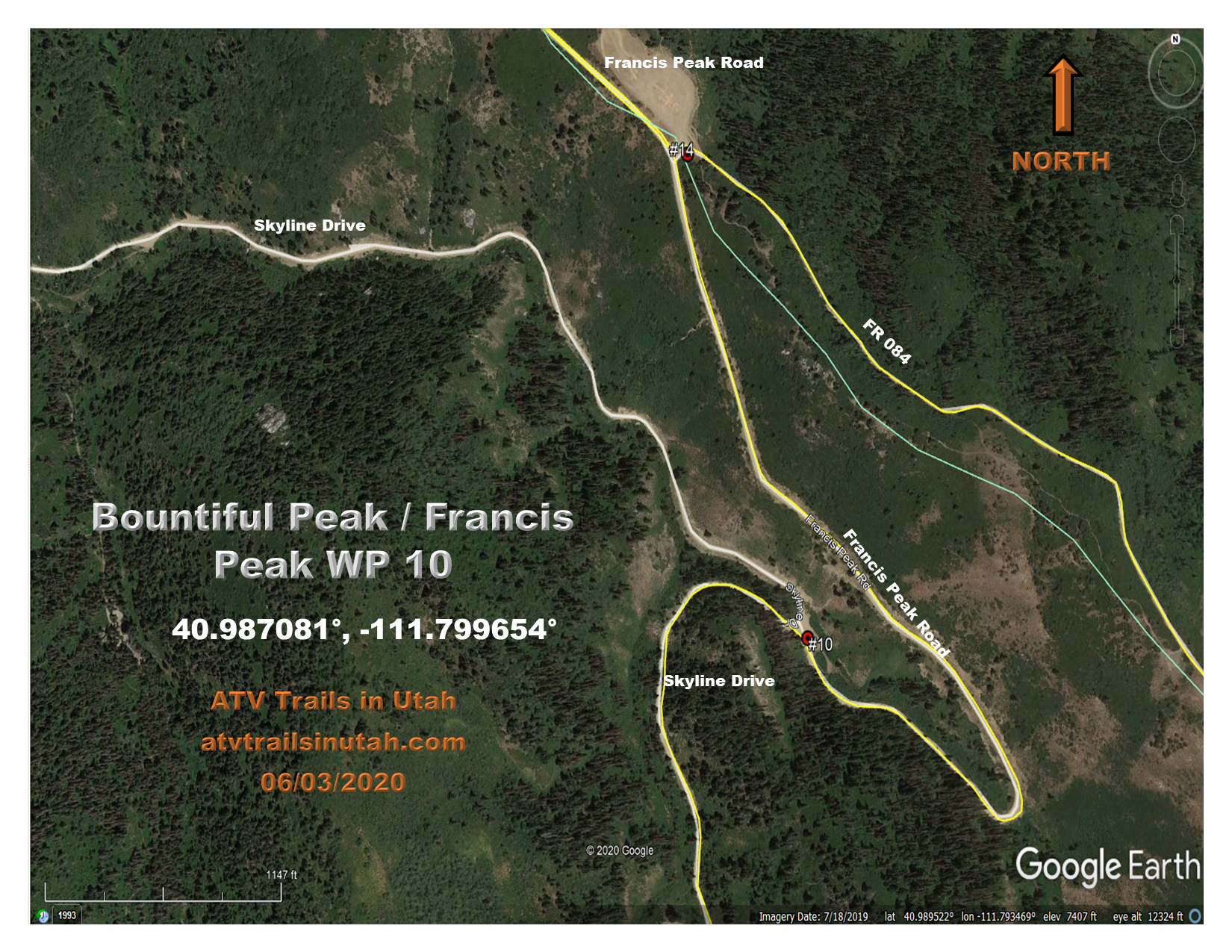
#9 At this point, you want to turn left toward Francis Peak Road (FR 009).(You will come back to this spot on the way back, traveling from the south out of Farmington Flats.) (Photo)
#10 At this intersection, stay right. You are now on Francis Peak Road (FR 009). 4.4 miles to Francis Peak from here. (Photo)
#11 There are some great views at this spot. The road to Francis Peak at this point is gated and locked. Stay right on FR 260. (Photo)
#12 At this fork in the road, stay right. This is the Smith Lakes Road FR 259. (Photo)
#13 This is as far as you can go. Have lunch here and look around before you start back. (Photo)
#14 At this big open space, leave the main road to the left and take FR 084 to Farmington Flats. This is approx. 6.9 miles from Smith Lakes. Use WP Map #5 for this part of the ride. (Photo)
#15 Stay right at this fork on FR 084 (Photo)
#16 Stay on the main road until you get back to WP #9. At WP # 9, turn left (east)and travel back to the staging area. (Photo)
We have provided several maps for your use. Study them carefully before you go on the ride for the first time. It is very important that you have some understanding of the ride in order to enjoy the ride rather than being lost. We have provided three types of maps:
– Digital Real-Time Waypoint maps of this ride detailing the route to travel
– USDAFS Motor Vehicle Use Map
– Topo maps of the area
All of the maps are images and are downloadable to a smartphone or a tablet. There are also photos of the POINTS OF INTEREST and Waypoint Descriptions. We suggest that you download the WP Maps, POIs, and WP Description photos to a smartphone or a tablet. You can print them on 8 1/2″ X 11″ paper if you prefer that over a smartphone or tablet. The Travel Maps and Topo Maps are large formats and will not print that well on 8 ½ x 11 paper but can be downloaded to a smartphone or tablet.
To download to your smartphone or device, open the website on your device. Next, open the trail package and then open the map on your device. Tap the screen and pick “Save Image” from the menu that comes up. The image is saved to your photos. This procedure applies to the Waypoint Photos too.
To print from your computer, right-click on the image. Click “Save Image as.” Select a file you want to save it in. Next, go to the file you saved the image in and double click. Your image should come up in a photo viewer of some kind. Follow the directions to print.
(CLICK ICON)
 Bountiful Peak/Francis Peak – 775 KB
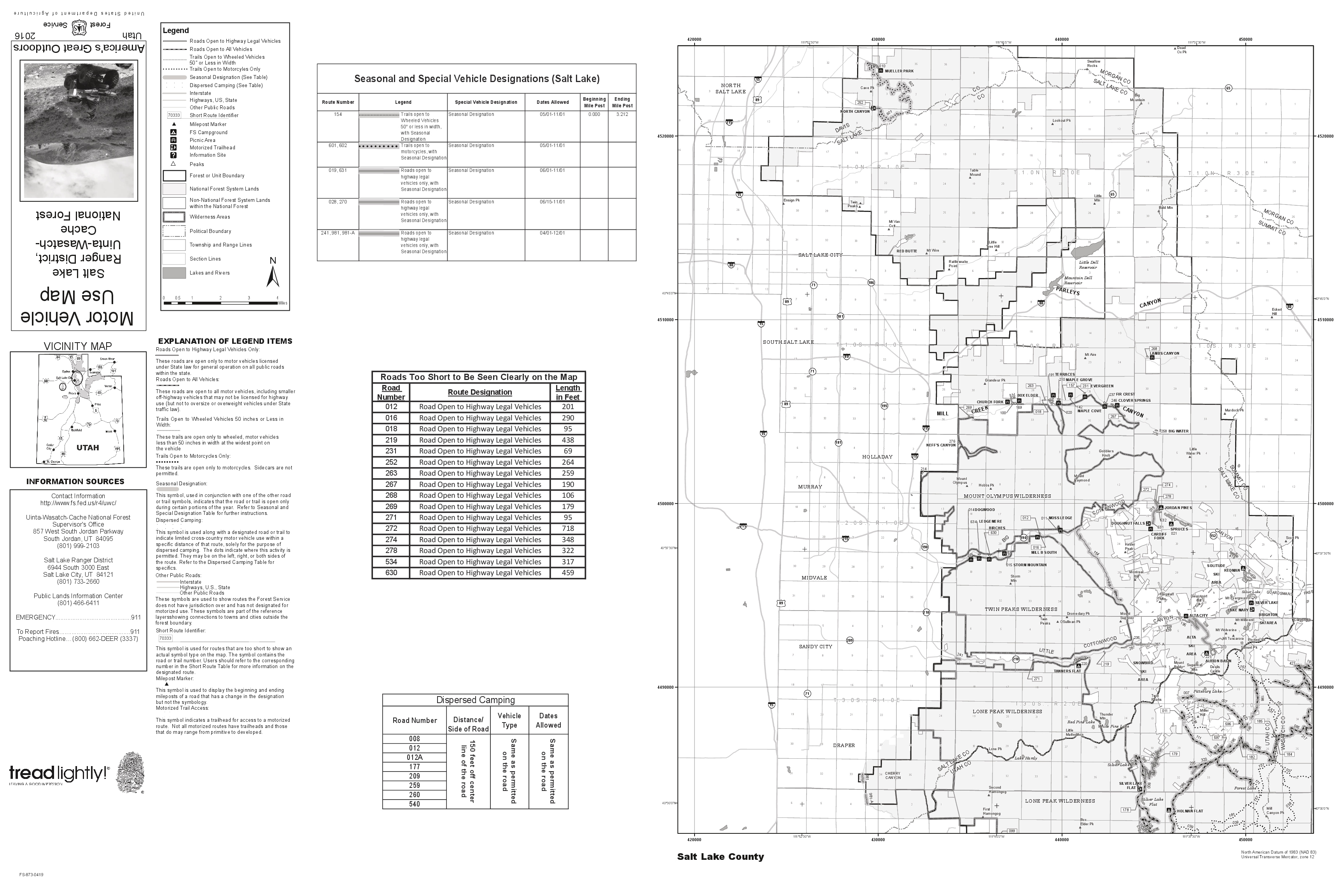 Salt Lake Ranger District #1 – 2.0 MB
 Salt Lake Ranger District #2- 2.0 MB
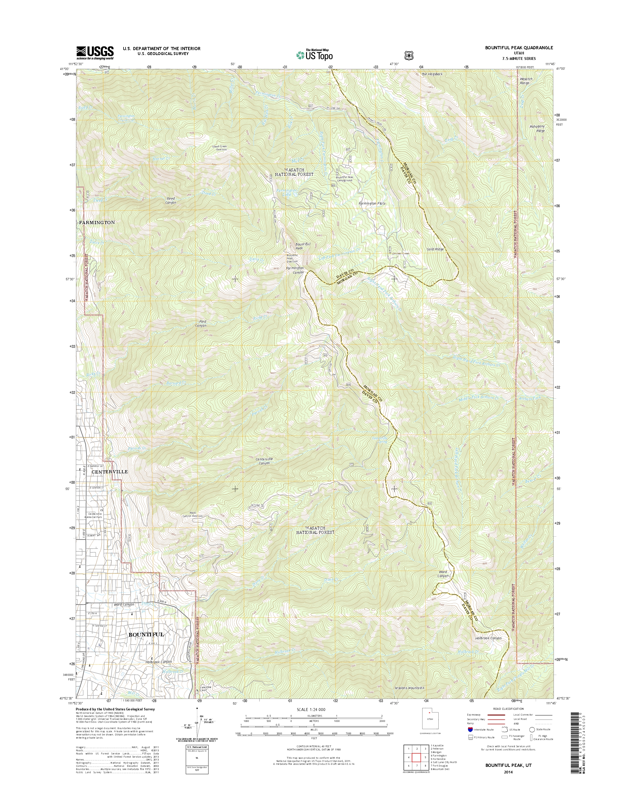 Bountiful Peak – 3.6 MB
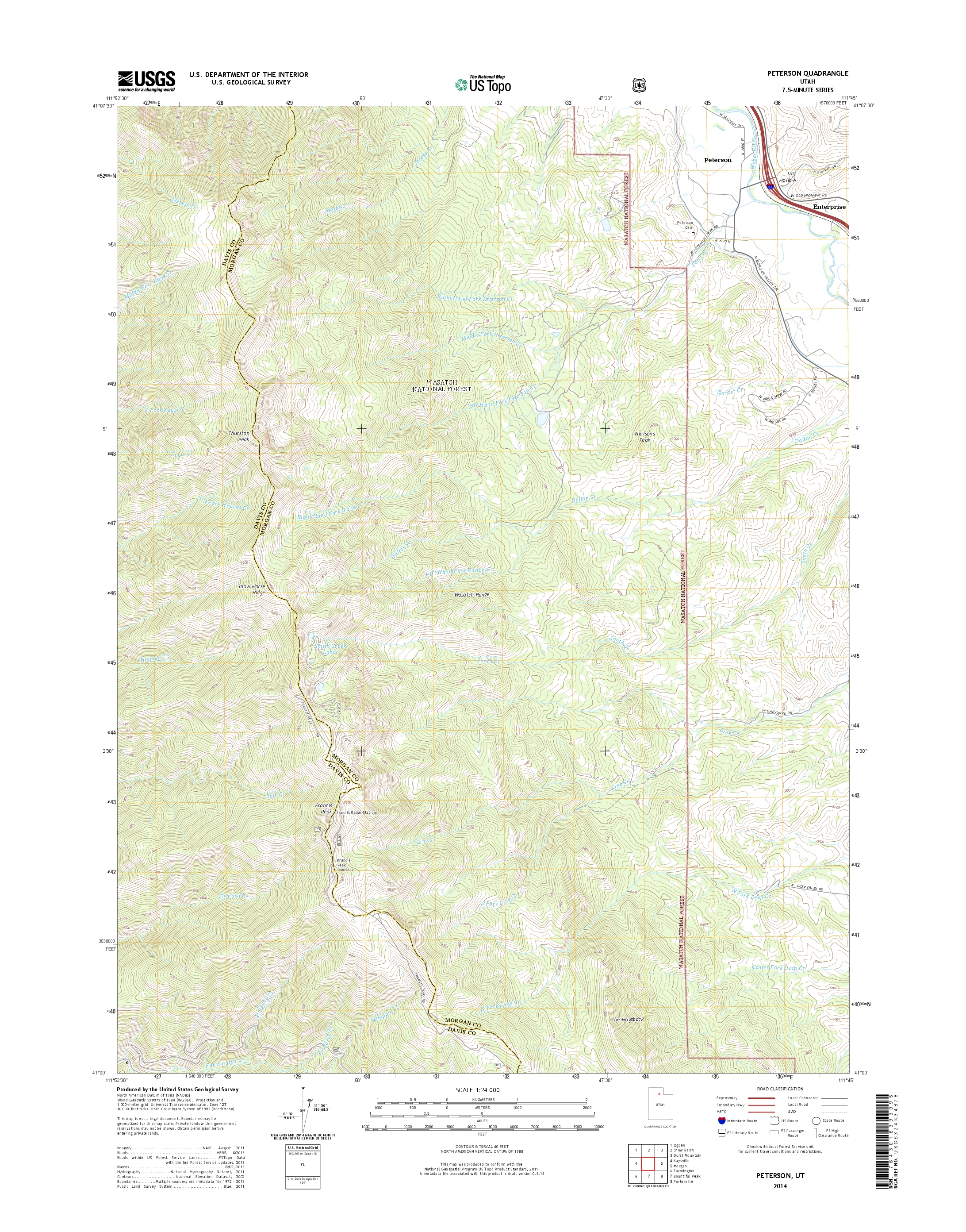 Peterson – 3.5 MB
 If you have a GPS, it can be very helpful to download a GPS Tracks file to it to help guide you on this trail ride. This is in addition to the maps we have already provided. Below, we have provided some popular GPS files for this ATV trail that you can download to your computer and then upload to your GPS. Instructions on how to do this are listed below. Please Note: (These instructions are for a Garmin Montana 610 series. You will be loading this file into Garmin BaseCamp. If you have a different GPS, you will need to consult that brand for instructions on how to upload your file. If you need a different file type other than what we have listed below, please contact us at info@atvtrailsinutah.com. We will provide you with a file format to upload to your brand of GPS.)
BOUNTIFUL PEAK / FRANCIS PEAK ATV TRAIL GPS TRACKS FILE
Bountiful Peak/Francis Peak GDB Format Garmin
Bountiful Peak/Francis Peak GPX Format
How to Download this GPS Tracks File to Your Computer.
How to Upload Your GPS Tracks File to BaseCamp.
(You will need to have the Garmin BaseCamp software loaded on your computer. If you don’t have BaseCamp loaded, then you will need to download the software and install it on your computer. It is free software. Download by clicking this link: Garmin BaseCamp )
Uploading the Trail File to the Garmin Montana 610.
Creating a Garmin Adventure: (Optional)
You can create a Garmin Adventure of the ATV Trail in BaseCamp. This allows you to travel the trail in BaseCamp. It’s a fun feature. You do this by:
To Play Back a Garmin Adventure Trail
In the left-hand column of BaseCamp is a box called “Garmin Adventures.”
 Part of enjoying a new ATV ride is being prepared. We feel that preparation should include a thorough study of the maps of the area before you go. Another valuable tool is Google Earth. By studying Google Earth, you will become familiar with the trail layout and surrounding topography that you will recognize when you are actually on the trail. This has helped us many times as we have traveled these trails for the first time.
Provided below is a Google Earth file that can be downloaded to Google Earth on your desktop or laptop computer. You will have a satellite view of where you are going and where exactly the trail is. This is a lot of fun to study and can be very helpful to you when you are out on the trail. You will be amazed at how often you will recognize different parts of the trail and feel like “you’ve been here before,” even when it is your first time because you have studied it beforehand. Instructions on how to download this file to the Google Earth trail file that is listed below.
If you do not have Google Earth on your computer or your mobile device, we have provided the following links so that you can download it.
(Click Here to Download Google Earth for Desktop & Mobile Device FREE)
Bountiful Peak / Francis Peak ATV Trail Google Earth Waypoint File
How to Download and Open this Google Earth Waypoint and Trail File
You download the Google Earth file by clicking the link above.
You will be asked to save it somewhere on your computer.
Make sure you save it in a place where you can find it because you will need it to upload to Google Earth on your computer. Now do the following:
Depending on your service provider, there are areas on this ride where you have cell service. Because cell service is limited, smartphone GPS apps don’t always work. If you want reliable GPS service, we recommend you purchase an actual GPS that works off of satellites. They do come in very handy if you are going to be doing a lot of ATV exploring. GPSs are very reliable but don’t completely replace knowing how to use topo maps and a compass. On occasion, they can take you to the wrong place.
You understand and agree that ATV riding can be a dangerous activity. ATV Trails In Utah is not liable for any damage or injury, including death, resulting from your use of any information found on this website. ATV Trails In Utah also disclaims any liability for direct, indirect, incidental, and/or consequential damages that arise as a result of your use of this website. By using this information, You agree to indemnify and hold ATV Trails In Utah harmless for all claims, injuries, damages, or costs (including attorneys’ fees) that arise from your use of this website, including for injuries and damages to anyone in your party.
While ATV Trails In Utah strives to keep the information on its website current, any information on this website is provided by ATV Trails In Utah as a courtesy only, and ATV Trails In Utah makes no representations or warranties of any kind, expressed or implied, about the accuracy, availability, or completeness of information with respect to the website. Any reliance you place on this information is strictly at your own risk (and all members of your party). You are responsible for obtaining, reviewing, and interpreting the maps and information at your own discretion. You must use the maps based on information available at the time of the ride and not use this information as any authorization or permission in any respect. Information and policies on the ground and/or on the trail always overrule information on this website, in writing, or on a map. You agree to not hold ATV Trails In Utah liability with respect to the accuracy or changing conditions.
07/10/2021 Added GPX file. Modified GPS Tracks first paragraph


